Report
Camiño dos Faros: Route, Map and Stages
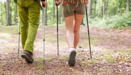
Discover this exceptional hiking route that runs along the Costa da Morte in 8 stages and 200 kilometers, from Malpica to Finisterre.
Índice

Sendero
What is the Camiño dos Faros?
The Way of the Lighthouses, more popularly known as 'O Camiño dos Faros', is an incredible and wonderful hiking route that runs along much of the coastline of the Costa da Morte, in the northwest of Galicia (province of A Coruña). It owes its name to the fact that it covers all the lighthouses along the route from Malpica de Bergantiños to the cape of Finisterre, and although it borders the sea, this does not mean that the route takes place on the beach.
O Camiño dos Faros enjoys a great number of landscapes, being beaches, cliffs, rivers, forests and dunes some of its main protagonists. All this through a route of 200 kilometres divided into 8 stages that runs along old fishermen's paths all along the Atlantic coast.
Why walk the Way of the Lighthouses?
At an average of 24.5 kilometres each, it is one of the best ways to discover the charm of the Galician Atlantic coast on foot. We don't say so ourselves, even the prestigious The Telegraph included the Camiño dos Faros among the best places in the world for adventurous tourism. The newspaper described the Galician coast as "dramatic", defining it as "dangerous for sailors" but "simply breathtaking for hikers".
However, it should be noted that the Camiño dos Faros is not a Jacobean pilgrimage route, i.e. it is not directly related to the Camino de Santiago. Still, it could be considered as one of the routes to consider for those pilgrims who want to know even more deeply the coast of A Coruña.
In short, it is a very little travelled hiking route in which we will border cliffs, cross forests and discover stunning beaches, always with the sea at our side, and concluding the experience at the cape of Finisterre, where we can enjoy one of the best possible views of the ocean in the area.

O Camiño dos Faros - Flickr Sermar
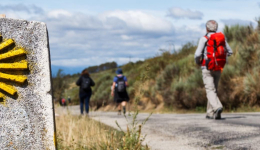
Stages of O Camiño dos Faros
The Way of the Lighthouses of the Costa da Morte is well signposted, with arrows and green footprints that pilgrims can see stamped on the rocks of the barnacle paths. In addition, it is a route of medium difficulty, which becomes more demanding as each day passes: each stage usually has a duration of 24.5 kilometres that can be completed in approximately 9 hours.
O Camiño dos Faros is an adventure of great ecological value due to the untamed areas we cross. If you are ready to embark on this unique experience, here are all the stages, as well as the details you should take into account in each one of them.
- Stage 1: Malpica - Niñóns (21.3 km)
- Stage 2: Niñóns - Ponteceso (27.1 km)
- Stage 3: Ponteceso - Laxe (25.3 km)
- Stage 4: Laxe - Arou (18 km)
- Stage 5: Arou - Camariñas (23.8 km)
- Stage 6: Camariñas - Muxía (32.6 km)
- Stage 7: Muxía - Nemiña (25.3 km)
- Stage 8: Nemiña - Finisterre (26.9 km)

Mapa de El Camino de los Faros - My Maps
Stage 1: Malpica - Niñóns
This is the first stage of the Camiño dos Faros. It has a total length of 21.3 km and a difference in height of 459 metres, although it has a 5 km stretch with significant climbs. It is worth it to be able to observe the spectacular views it offers. You will pass by 6 beaches: Area Maior, Seaia, Beo, Seiruga, Barizo and Niñóns, as well as incredible cliffs and other points of interest such as the Sisargas Islands or the coast of Nariga.
Stage 2: Niñóns - Ponteceso
This second stage connects Niñóns with Ponteceso, along the coast. It consists of 27.1 km with a harder first section, approximately from kilometre 7 to 10, and a flatter second part. Accumulating a difference in altitude of 516 metres. Its landscapes are wonderful, as you will pass by Cabo Roncudo to see the cliffs, you will also see coves and walk along the Ría de Laxe to the dunes of A Barra.
Stage 3: Ponteceso - Laxe
The route from Ponteceso to Laxe turns inland to see the Dombate Dolmen and the Borneiro Hillfort. You will be at the highest altitude of all the stages at Monte Castelo de Lourido. The stage accumulates a little more than 25 km with a climb in the first stage, and a difference in altitude of approximately 217 km. There are more road sections than in the previous two stages, making it more bearable.
Stage 4: Laxe - Arou
The Laxe-Arou stage could be considered the shortest and easiest, although the scenery is worth the effort. The difference in altitude is 204 metres out of 18 km, which makes it a good option to do in one day and get the most out of it. You will be able to see the Laxe Lighthouse, the Soesto Rock, the Praia dos Cristais, the Praia de Traba and also the Man Museum.
Stage 5: Arou - Camariñas
This stage is harder than the previous one, but just as impressive. It covers a total of 23.8 kilometres with an elevation gain of 296 m. You will be able to see places such as the Praia de Lobeiras, the Duna de Monte Branco, the Cementerio dos Ingleses or the Vilán Lighthouse before entering Camariñas.
Stage 6: Camariñas - Muxía
Camariñas - Muxía is the longest stage of all, but also the flattest. It is about 32 kilometres with a difference in altitude of 470 metres. The other routes go along the more rugged and unpopulated coastline, while on this route you will go along the Camariñas estuary and pass through numerous villages. The points of interest you will come across are: the Sanctuary of Virxe da Barca, the lighthouse of Muxía and the beaches of Area Grande, Leis and Lago.
Stage 7: Muxía - Nemiña
This stage connects Muxía with Nemiña along the coast. It is much steeper than the previous stage. It consists of about 25.3 km with a level of 912 metres. The section is hard until you pass Praia de Moreira, from there it becomes flatter. As for the scenery, it is spectacular, just like the rest of the stages.
Stage 8: Nemiña - Finisterre
The last stage is tough but incredible. With 26.9 kilometres in total and a difference in altitude of 815 metres, which is especially concentrated in the second stage. You will be able to see cliffs, beaches and points of interest such as the Castro de Castromiñán, the Monte do Facho, the Ría de Lires and the Fisterra Lighthouse.
Related
Latest blog
Tips
Curiosities
Routes
Blog
 ¿Vas a hacer el camino de Santiago? Cuida tus pies antes y después
 5 razones por las que contratar un seguro de viajes
 Formas de hacer un logotipo
 La importancia del registro de llamadas durante tu viaje por el Camino de Santiago
Information
Points of interest
Cities & Towns | Hostels | Lodgings | Restaurants | Saddlery | Doctors | Points of interest | Bikes workshop
Contact us | Privacy policy | Cookies policy | | Terms of use | Authorship | Web Map | Consentimiento
© Copyright LA VOZ DE GALICIA S.A. Polígono de Sabón, Arteixo, A CORUÑA (ESPAÑA) Inscrita en el Registro Mercantil de A Coruña en el Tomo 2438 del Archivo, Sección General, a los folios 91 y siguientes, hoja C-2141. CIF: A-15000649