Information

On the descent walkers will observe the Reservoir of Fervenza
Without doubt this is one of the stages of greatest beauty on the journey, despite its excessive length that is likely to leave most pilgrims exhausted and with the feeling that the last few kilometres are endless. One option is to end the day in Santa Mariña, 20 kilometres from the start, although the small size of this enclave may discourage more than one walker from doing so. Either way, recommendations are to make a stop in this enclave, with bars, because from here and, for 11 kilometres, there are no other services. A stage to be taken with calm, on which, walkers can enjoy the panoramic views of lush greenery and over the Reservoir of Fervenza.
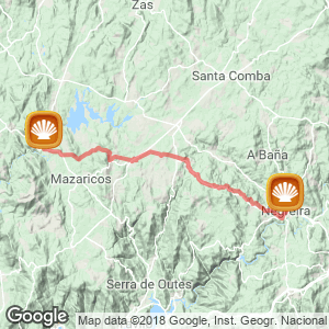
The stage (33 kilometres)
The itinerary departs from the centre of Negreira. However, those walkers who slept in the public albergue, situated on the outskirts of the centre, will already have covered the first stretches on the previous stage. After passing the street of avenida de Santiago walkers should turn left and continue in descent on the road of San Mauro (the original Camino). From here walkers pass the square of Cotón, the DP-5601 and, Negreira, where the public albergue is situated. However, the ancient route (well signposted with a milestone) deviates pilgrims a little before towards the right.
Sections of the old original Camino Later, in Cornado there are no services for walkers. In Mo, on the pilgrim route itself, walkers will find a number of rural tourist houses they include Casa Jurjo and the rural hotel of Santa Eulalia. In the surrounding area of the location there is also Casa Pepe, with a bar.
A little later the route arrives at a dangerous junction with the AC-400, the road that should be taken to the left, in the direction of Pino do Val/Muros. On continuing hikers reach the albergue of Santa Mariña (with the café-bar Antelo) and the café Victotoriano, with a bar and sandwiches. Those walkers lacking in provisions are strongly recommended to make a stop at this place as for the next 11 kilometres there are no other services. In this location pilgrims will find a bakery and the bar Gallego, from here the route, well signposted, takes a turn off on asphalt to the right.

Ponte Olveiroa
Related route
Location
Related Cities & Towns
Stage profile

Routes
Blog
 How to get to Sarria to do the Camino de Santiago
 Descubre la magia del Camino de Santiago Portugués por la costa
 5 tours culturales que puedes hacer en Galicia si decides hacer un alto en el camino
 Doing the Camino de Santiago in June: What you should know?
Information
Points of interest
Cities & Towns | Hostels | Lodgings | Restaurants | Saddlery | Doctors | Points of interest | Bikes workshop
Contact us | Privacy policy | Cookies policy | | Terms of use | Authorship | Web Map | Consentimiento
© Copyright LA VOZ DE GALICIA S.A. Polígono de Sabón, Arteixo, A CORUÑA (ESPAÑA) Inscrita en el Registro Mercantil de A Coruña en el Tomo 2438 del Archivo, Sección General, a los folios 91 y siguientes, hoja C-2141. CIF: A-15000649
Developed and managed byHyliacom