Information

Un peregrino fotografía la catedral de Santiago oculta tras la niebla / Fotografía de Sandra Alonso
For many pilgrims a desire to reach Santiago and complete the route will encourage them to advance quickly through this simple stage with moderate slopes, apart from some sections where urban pressure makes this prelude to Santiago less attractive. For others, however, discouraged to see the Jacobean adventure end, will take these last steps slowly. This final stage passes through leafy tracks and enclaves of clear Jacobean influence that offer limited services. Lavacolla, where the pilgrims of old stopped to wash their bodies from head to toe in order to arrive in Santiago clean, or Monte do Gozo, a small hill from which the, still distant towers of the cathedral can be seen, gradually the walkers approach their goal along this last urban route. The Camino approaches Santiago through the neighbourhood of San Lazaro, converted into an authentic area of services, after passing Avenida do Camino Frances, a street that pays homage to the route itself, the walkers approach the historical centre. After a short walk they enter its monumental area, now situated at the foot of the cathedral. Santiago compensates the pilgrims for all their efforts.
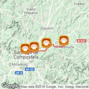
The step (21,1 kilometres)
With their minds set on Santiago, departing from Pedrouzo (21.1 Kilometres to Santiago) the last stage of the French way begins, a journey that should be started early in the morning to ensure arrival to the pilgrim mass, which takes place at 12.00 in the temple of Compostela. From the Xunta hostel or if preferred, walkers can go back 600 meters to rediscover the official route, which runs parallel on the north side of the town, alternatively, hikers can continue on the road and, on reaching the bar Pedrouzo should turn right to arrive at a football pitch. From here the route turns left and continues on an earthy path until reaching San Anton (18.8 kilometres to Santiago), a hamlet situated in the valley of the river Brandelos. It was here that in 2008 Felix Menchacatorre, a pilgrim from Guecho, 59 years of age, and a USAC director for Spain- (an American consortium, which each year brings hundreds of students from the USA to the Basque community) -died while leading a group of students to Santiago. A monument was erected in his memory.
The route then proceeds along what will be the last great oak wood on the ancient Camino, on a path that alternates between asphalt and earth. The itinerary borders the fort of Amenal (16.8 kilometres to Santiago) and situated at the top, the town itself, in its centre the pilgrims will not find a great range of services. However, they will encounter facilities a few meters later, after crossing the River Brandelos, and the N-547 via an underpass, now, at the other side of the road, the walkers arrive at the hotel Amenal, with breakfast served from 06.00 hours, menus and rooms. The walkers now embark on a shaded path and face the most difficult slope of the day, the stretch that leads to Cimadevila, a steep and constant slope, initially, which becomes less pronounced towards the end. The climb continues on a forest track for two kilometres until reaching the summit, situated at 360 metres. The pilgrims now trace the contours of the Council of Santiago and its airport, a building that connects the two main roads and has forced drastic modifications to the original layout of the ancient Camino.
A number of crosses have been deposited by pilgrims on a fence that surrounds the airfield, (now leaving the path on the left) an attempt to sweeten this sad finishing to reach the goal. In the area of a roundabout, where the N-547, N-634 and Santiago-Lugo motorway meet, a monolith with a staff, a pumpkin and a scallop shell, one of the most photographed monuments by walkers-announces the entrance to the borough of Compostela. The pilgrims border the right side of the airport terminal on an uneven path that is in bad condition. In times of heavy rain this stretch accumulates mud, making it difficult for walkers to pass and, even more so for cyclists. Via Lavacolla After crossing a secondary road and continuing the journey under some vines the travellers reach the rural enclave of San Paio (12.5 kilometres to Santiago), clustered around its stone temple. Here pilgrims can take a break on a seat next to the milestone of the enclave or can replenish strength at the restaurant Porta de Santiago.
The journey resumes with a difficult stretch on a neighbouring road that connects to another path, well signposted, it branches off to the right and later proceeds straight ahead among eucalyptus and pines. A little further on, and now in descent, the route crosses the motorway via an underpass and continues ahead on a narrow but clear path. At a crossroads the path veers to the left, on a stretch of asphalt until reaching A Esquipa, Its surroundings are often confused with those of Lavacolla (10.5 kilometres to Santiago). The path boarders around a school and, encounters, on its advance, a fruit shop, the coffee bar A Concha- with breakfast served from 07.00 hours, a pilgrim menu and rooms-on its right the restaurant San Paio, it also offers lunch and pilgrim menus. In this area walkers will also find one of the most famous hotels in Santiago, Ruta Jacobea, an establishment frequently used for baptisms, first communions and weddings. The Camino reaches a curve to the left and it approaches, via some stairs, the area of a music stand and the church of San Pelayo de Sabugueira, built in 1840. The trail borders the temple and its adjoining cemetery and reaches a junction with the N-634, known by locals as the Lavacolla road. Continuing in the direction of Vilamaior, now at the other side of the asphalt, walkers encounter a grocery shop, a drinks machine, a bar and, less than 100 meters in distance, the River Sionlla, one of the most famous on the pilgrimage route, here the pilgrims partook in the old, traditional and hygienic custom of shedding their dirty clothes and washing, not just their private parts but their entire bodies in preparation for their imminent arrival to Santiago. This comprehensive washing practice was also common in various hospitals on the Camino of Santiago, most historically, those of Navarre.
The Codex Calixtino recounted this: Among the freshwater rivers and healthy drinking water is Labacolla, beneficial because it passes through areas of lush landscape, two kilometres from Santiago, French pilgrims on route to Santiago, removed their clothes and for their love of the Apostle, would not only wash their intimate parts but their whole body. (Chapter VI of book V of the Codex Calixtinus) The name Lavacolla derives from the verb lavar (to wash). However, and despite the widespread belief its origin stems from a combination of both lavar and collóns (testicles) or in Galician language cojones, the governing body of Galician language does not confirm this hypothesis. After crossing the river the walkers begin a fairly difficult and steep slope on asphalt that continues for over half a kilometre until reaching Vilamaior, where it eases. In this centre the pilgrims can make another brief stop in casa Amancio, an establishment with rooms, a pilgrim menu and Wi-Fi. Shortly after and, on a straight path they reach Neiro, where the headquarters of the TVG (Television of Galicia) is situated, it is passed on the right, and a few meters later they arrive at the campsite of San Marcos. After a left turn, the route skirts around the TVE building and passes La Lagunita, an equestrian centre, open 24 hours, and in which pilgrims often leave their horses before arriving to Santiago.
The entrance in Santiago The pilgrims now approach the vicinity of San Marcos (5.1 kilometres to Santiago), a small centre with services both at its entrance-establishments offering affordable menus, pizzas, sandwiches or breakfast-and in its centre. Following the path straight ahead they arrive at a chapel, from here they turn left and approach one of the greatest icons on the ancient road, Monte do Gozo (Montjoy, Montxoi or the hill of San Marcos). At the summit of this small hill, 380 meters in altitude, the pilgrims, for the first time, have a distant view of the towers of the cathedral, the mount is appropriately named, Monte do Gozo, meaning Mountain of pleasure or merriment. History recalls how French walkers, on glimpsing the mount, shouted "Mon joie! Mon joie!" And ran, on a race to its peak. The first to arrive was hailed as king of the pilgrimage by their fellow pilgrims. Several studies suggest that the French surnames Roy and Leroy, and Rey, Spanish, originate from this fact. At the top of the mount a commemorative monument was erected on the visit of Pope John Paul II to Santiago in 1982, during the Holy Year. It is a work by the Brazilian artist Yolanda D'Augsburg Rodrigues. On a stone base rises a towering sculpture with a cross and a shell, guarded by two pilgrim figures. The pedestal is decorated with different images, which reproduce in iconographic form of the visit of the supreme pontiff to Compostela. Monte do Gozo was reconverted in the Holy Year 1993 into a residential area for pilgrims and visitors, as well as a place of meeting and enjoyment, from this point the pilgrims embark on an urban stretch that will take them to the gates of the cathedral of Santiago.
With Santiago in sight, an asphalt path borders the left side the resort of Mount Gozo, including the hostel and complex with the highest room capacity (400 beds), various rooms, a campsite and a restaurant, and after passing some stairs-that cyclists should avoid by continuing on the road-they reach the neighbourhood of Lazarus. The route crosses a roundabout, and the AP-9, and leads the weary pilgrims to the park, Camino de la Concorde, which recalls the award presented in 2004 by the Prince of Asturias to the ancient Camino. In this garden area there also stands ' Porta itineris Santi Jacobi', a sculpture by the Santiago born artist Cándido Pazos, a symbol of the doorway to the Camino of Santiago, which opens to the city of the Apostle.This area has experienced a tremendous growth in recent years. Located here walkers will find the Palace of Congress and Exhibitions as well as various Galician government buildings, such as the General Department of Forestry, which occupies one of the most historic buildings in the centre, the old San Lazaro Hospital (a former hospital for leprosy), restored in XIX century. A few meters later, and after passing several establishments where it is possible to eat at a reasonable price, the pilgrims find the chapel of San Lazarus, from the mid XX century.
They continue on the avenue Camiño Francés, named so because it is the gateway to the ancient route, and after zigzagging through several bends they arrive to the neighbourhood Os Concheiros, where there are stalls selling scallop shells to the recently received pilgrims. This tradition led to the visiting pilgrims being referred to as "concheiros" (shell carriers) by the locals. In Santiago After climbing a few meters hikers reach the small square of San Pedro, where there is a cross, and from which the walkers can already see the cobbled streets and monumental buildings in the heart of the enclave. Continuing down the street of San Pedro, on irregular asphalt they reach several of the most popular restaurants and bars in this traditional Galician capital, and come to the Porta do Camino, one of the most historic entrances to the old walled city. Once this last step has been passed, the route enters the historic centre along the Calle Casas Reais, where once stood the money changers guild and where pilgrims will discover the imposing chapel As Animas, to arrive immediately afterwards, to the Plaza de Cervantes, the first major historic meeting place and trading area of the city and home to the town hall until the XVIII century.
The towers of the Cathedral stand majestically before the proud on looking pilgrims, whom now see their pilgrimage as complete. All that remains is to walk few meters down the street Calle A Acibechería (the place where many artisans of jet stones can be found) and leaving on the right the imposing facade of the ancient monastery of San Martiño Pinario (XVII-XVIII centuries), which hides one of the most impressive cloisters in Galicia. The cathedral is situated just ahead, to the left of the walker, which, if following the traditional path, must be entered through this door, A Acibechería, referred to in the Codex Calixtino as Puerta Francígena. Currently, however, there are many pilgrims who choose to prolong their arrival a few more steps. Passing the arch down to the square Praza do Obradoiro and from here they stand in front of the spectacular baroque facade of the temple. Only during Holy Years should the pilgrims enter the basilica via the Holy Door, located in the square Plaza de A Quintana, which is only open during these dates. The End of the Road.
By bike
Without major difficulties in terms of terrain, the final leg of this journey can be difficult for cyclists in certain stretches, such as the steep and rocky climb from Amenal to Cimadevila. The Camino passes small streams and rivers and this succession of ups and downs makes the journey more difficult, especially after periods of heavy rain. On the path that borders the Airport in Lavacolla cyclists may have to dismount at times when the ground makes it impossible to continue the journey.
Related route
Location
Related Cities & Towns
Stage profile

Routes
Blog
 How to get to Sarria to do the Camino de Santiago
 Descubre la magia del Camino de Santiago Portugués por la costa
 5 tours culturales que puedes hacer en Galicia si decides hacer un alto en el camino
 Doing the Camino de Santiago in June: What you should know?
Information
Points of interest
Cities & Towns | Hostels | Lodgings | Restaurants | Saddlery | Doctors | Points of interest | Bikes workshop
Contact us | Privacy policy | Cookies policy | | Terms of use | Authorship | Web Map | Consentimiento
© Copyright LA VOZ DE GALICIA S.A. Polígono de Sabón, Arteixo, A CORUÑA (ESPAÑA) Inscrita en el Registro Mercantil de A Coruña en el Tomo 2438 del Archivo, Sección General, a los folios 91 y siguientes, hoja C-2141. CIF: A-15000649
Developed and managed byHyliacom