The Camino de Santiago by bike
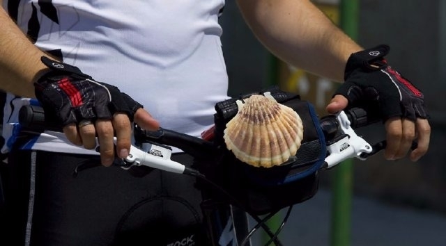
At least one in ten pilgrims of the Camino de Santiago who reach Plaza del Obradoiro do so on two wheels. Each of these bicigrinos (cycling pilgrims), as they are popularly known, presents different characteristics depending on their age, strength, weight, type of bike, etc … For this reason, it is extremely difficult to categorize the journeys.
Choosing doing the Camino de Santiago by bike is very interesting alternative for those pilgrims who want to travel long distances, but not want to give up everything imbibe the infinite attractions that hides the pilgrimage route. The bike also gives us more possibilities for luggage if walking pilgrimage thanks to the possibility of installing saddle bags and baskets in which distribute weight normally get along in the backpack.
However if we choose to make the Santiago Way bike and become a bicigrino, we need to know some basics of maintenance, in addition to not forget certain multipurpose tools, flanges, pump or patches to fix flat tires, something that is essential for get ahead. We should not think on the other hand to go on a bicycle we save all the effort to make the Camino de Santiago walk, as it remains intense physical exercise, having to face significant increases in certain fearsome stages. Therefore we must always keep an eye on our physical and mental state, hidratándonos, heating and stretching after each stage to avoid injury.
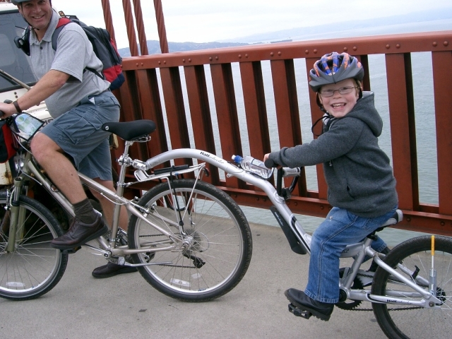
The pilgrim who choose to do the Camino de Santiago by bike is not free from the hazardous weather, so that essential elements such as rain coat must be added other specific of this transport, as covers for the mud. On the other hand, one of the great advantages you will find the pilgrim on the bike is its adaptability and can even install trailers or transport chairs for children if the situation requires.
Finally, if you've already decided before leaving home you must plan how you want to transport your bike, as there are multiple options, depending on whether you want to travel to the starting point of the Camino de Santiago by bike or prefer to send and collect it there , making you really more comfortable ride. If you choose this second option, you should know that there are a variety of services with very competitive prices that keep you from headaches, such as running out of room and deniegen you to upload your bike on the train or bus.

37.99€45.99€
Ahorras: 8 (17.4%)
amazon.esThe stages of the Camino de Santiago by bike
In Vive el Camino we present you a structure divided into 15 stages starting in Saint Jean Pied de Port and finishing in Santiago. The average kilometres for each day are just over 52, although this figure may be misleading. Each day has been rated according to its difficulty and related distance, for this reason, the first stage consists of only 26 km. It is the shortest of all, but the steep Pyrenean slopes faced by the pilgrims will leave many squirming over the handlebars, while others may even have to dismount to reach Roncesvalles. By contrast, the stage linking Burgos to Carrión de los Condes consists of 86 kilometres. During which there are hardly any slopes, so riders can pedal away without a problem.
Similarly, and although many pilgrims choose to remain on asphalt, this guide is intended for those following the Original Way, while it is true that sometimes, due to unavoidable difficulties, exceptions are made and directions are provided to continue on the road.
Of course, this section is intended to serve as a reference. It can be changed at the whim of each cyclist. Those who arrive at the finish with strength can continue some kilometres and, those who falter before arriving should not feel forced to finish. They are likely to find a hostel or alternative accommodation before the end of the scheduled journey.
Index of stages by bike
1.Saint Jean Pied de Port, Roncesvalles (26 kilometres)
Minimum height: 233 meters
Maximum height: 1480 meters
Difficulty: Very high
It is possible to cover this stage by passing through the town of Valcarlos. The journey is a little longer, but easier and without having to leave the tarmac. Either way, and although you will end up suffering, with good weather conditions the route through the Cize ports is recommended. For more information, see the section titled ” bike ” stage 1.
2. Roncesvalles, Pamplona (48 km)
Minimum height: 962 meters
Maximum height: 449 meters
Difficulty: Very high
Despite descending more than 500 meters from beginning to end, the first stretch of this stage is tremendously complicated. It is the perfect example of a leg breaking stretch, in which steep slopes are interspersed with hell like climbs and with hardly any areas on flat terrain. In some parts the bad ground makes the task even more difficult, but nothing that a mountain bike can’t handle. The descent from the peak of Arre to Zubiri should be done on the road because it is extremely dangerous. The second half is considerably easier. For lovers of cycling, the route passes through Villava, the birthplace of Miguel Indurain, five-time champion of the Tour de France.
For more information, see the section “By bike” stages 2 and 3.
3. Pamplona- Estella (44 kilometres)
Minimum height: 397 meters
Maximum height: 780 meters
Difficulty: High
This stage is most notable for the ascent and descent of Alto del Perdon. The difficulty involved should be taken without haste. The heavy winds and loose ground complicate the climb. The descent is very dangerous and, it is therefore recommendable to use the road. The rest of the stage does not present great difficulties, although the arrival to Estella is somewhat complicated.
For more information, see the section on ‘ by bike’ of stages 4 and 5.
4. Estella –Logroño (49 kilometres)
Minimum height: 420 meters
Maximum height: 590 meters
Difficulty: High
A very comfortable stage with the exception of the ascent to Villamayor de Monjardín, short but demanding, and the section between Torres del Rio and Viana is sheer torture filled with steep descents which require good brakes. Many cyclists end up continuing this stretch on the road.
For more information, see the section “by bike” of stages 6 and 7.
5. Logroño -Santo Domingo (48 kilometres)
Minimum height: 390 meters
Maximum height: 715 meters
Difficulty: Medium
This stage runs through the valley of Ebro, an area where high winds are common. The ascent to the peak of San Anton is the most notable difficulty.
For more information, see the section” by bike” stages 8 and 9.
6. Santo Domingo de La Calzada- Burgos (75 kilometres)
Minimum height: 640 meters
Maximum height: 1165 meters
Difficulty: Very high
One of the most complicated stages due its length and the difficulty of the second half. The ride to Montes de Oca is comfortable, although, riders will face long slopes. Before arriving to Burgos they have to cross the Sierra of Atapuerca, which is complicated by irregular and stony terrain. The access to Burgos is through an industrial estate, which is dangerous because of heavy traffic.
For more information, see the section” by bike” stages 10, 11 and 12.
7. Burgos, Carrión de los Condes (86 kilometres)
Minimum height: 640 meters
Maximum height: 1165 meters
Difficulty: Medium-High
The longest stage but dominated by flat terrain. The only port, Mostelares is situated half way through the stage, just at the exit of Castrojeriz. It is worth taking things easy as the last part of the journey involves some demanding slopes. Now in Tierra de Campos, before arriving to Frómista, a pretty walk along the banks of the English Channel. For more information, see the section ” by bike ” stages 13,14 and 15.
8. Carrion de los Condes -Sahagún (39 kilometres)
Minimum height: 830 meters
Maximum height: 910 meters
Difficulty: Very Low
This transitional stage could be described as practically a rest. Pilgrims will have the opportunity to spend the day in Sahagun. Very short in distance and without any difficulties to face, the layout of the journey looks as flat as a plate. It is worth taking the opportunity to relax and recharge your batteries before confronting the second week of the Camino de Santiago.
For more information, see the section ” by bike ” stages 16 and 17.
9. Sahagún -León (57 kilometres)
Minimum height: 800 meters
Maximum height: 910 meters
Difficulty: low
After the break on the previous day, the pilgrims return to enjoy a smooth journey to relax their legs. The profile is very flat. The moors of Leon in summer can be torturous because of the high temperatures reached in the area. The variant, via Calzadilla de los Hermanillos is a couple of kilometres longer.
For more information, see the section” by bike ” stages 17 and 18.
10. León- Astorga (Kilometres)
Minimum height: 800 meters
Maximum height: 950 meters
Difficulty: Easy
Another very achievable stage both in terms of distance and profile. The terrain becomes flatter as the traveller approaches Astorga. Crossing the Bridge Paso Honroso by bike, despite the irregular stony ground, it is likely to become one of those moments that will be remembered for life.
For more information, see the section” by bike ” stages 19 and 20.
11. Astorga – Ponferrada (54 kilometres)
Minimum height: 500 meters
Maximum height: 1504 meters
Difficulty: High
The end of the moor. The route passes through the infinite flat terrain to the highest point on the whole French Way in Spain and, all in the blink of an eye. The legs suffer once again during the climb. Lactic acid makes a re appearance. The descent is really dangerous. To not descend on the road would be completely irresponsible. A great deal of caution is required on the descent from El Acebo to Molinaseca. A monument at the foot of the Camino reminds travellers of one of the latest victims, a pilgrim German.
During the climb, there are sections with road markings, where it is also advisable to continue on the asphalt.
For more information, see the section ” by bike ” stages 21 and 22.
12. Ponferrada -O Cebreiro (50 kilometres)
Minimum height: 460 meters
Maximum height: 1320 meters
Difficulty: Very High
Along with the baptism of fire in the Pyrenees of Navarre, this day is truly the queen of stages of the Camino de Santiago. The mountain is at its finest. The climb to O Cebreiro is not without its difficulties, it can be completed on the traditional path, but to leave Las Herrerías, the last village before the ascend, there are several signs painted on the asphalt to direct cyclists. The arrival to Galicia compensates the suffering. Except for the arrival to Villafranca, with the odd slope, the first section of the stage is peaceful. It is worth reserving strength for the last few kilometres.
For more information, see the section ” by bike ” stages 23 and 24.
13. O Cebreiro – Sarria (40 kilometres)
Minimum height: 450 meters
Maximum height: 1330 meters
Difficulty: Medium
There is a steep slope to crown the peak of Poio. From this point the descent begins. The arrival to Triacastela is complicated due to stony slopes. From this village there are two possibilities to get to Sarria. The original one runs through San Xil, somewhat shorter but also with a demanding section. The other variant passes through Samos, the location of the famous monastery.
For more information, see the section” by bike ” stages 25 and 26/27
14. Sarria – Palas de Rei (40 kilometres)
Minimum height: 360 meters
Maximum height: 730 meters
Difficulty: Medium
This stage can only be described as short but treacherous. The first stretch is smooth but can become complicated in times of rain because the ground can become muddy and, to unimaginable levels in rural Galicia. Towards the end of the placid descent to Portomarín the most complicated and demanding stretch of the stage begins, on uneven ground and with considerable slopes.
For more information, see the section ” by bike ” stages 28 and 29.
15. Palas de Rei -Santiago (69 kilometres)
Minimum height: 290 meters
Maximum height: 560 meters
Difficulty: Medium- High
The last day’s march and, the point at which energy levels begin to falter but having Santiago a stone’s throw away encourages you to make one last effort. The climb to Arzúa has complicated slopes comparable to the legendary climb to Monte do Gozo. The distance is considerable. Also bear in mind that some areas may be very muddy.
For more information, see the section ” by bike ” stages 30, 31 and 32.

Routes
Blog
 How to get to Sarria to do the Camino de Santiago
 Descubre la magia del Camino de Santiago Portugués por la costa
 5 tours culturales que puedes hacer en Galicia si decides hacer un alto en el camino
 Doing the Camino de Santiago in June: What you should know?
Information
Points of interest
Cities & Towns | Hostels | Lodgings | Restaurants | Saddlery | Doctors | Points of interest | Bikes workshop
Contact us | Privacy policy | Cookies policy | | Terms of use | Authorship | Web Map | Consentimiento
© Copyright LA VOZ DE GALICIA S.A. Polígono de Sabón, Arteixo, A CORUÑA (ESPAÑA) Inscrita en el Registro Mercantil de A Coruña en el Tomo 2438 del Archivo, Sección General, a los folios 91 y siguientes, hoja C-2141. CIF: A-15000649
Developed and managed byHyliacom
